The Heat Vulnerability Project is working in collaboration with the Department of Communities and the Department of Health to better understand and address high heat across Western Australia. The National Disaster Risk Reduction (NDRR) funded Heat Vulnerability Project will map high heat risk regions against heat-vulnerable populations across WA. This project works closely with local government and community organisations across pilot sites to ensure the development of heat interventions are what community want and need. The project evaluation report will provide recommendations to prevent unnecessary heatwave deaths and health implications across WA that can also be applied by other jurisdictions.
The City of Rockingham (Whadjuk and Pinjareb Nyoongar Country), The Town of Bridgetown/Greenbushes (Wardandi and Pibulmen Nyoongar Country) and The Town of Port Hedland (Kariyarra Country) are the three pilot sites.
The project has engaged with expertise from across a wide range of groups, institutions, and departments including the Aboriginal Health Council of Western Australia, the Bureau of Meteorology, the Climate Justice Union, Departments of Communities, Fire and Emergency Services, Health, and Water and the Environment, University of Curtin, Linkwest, and independent experts.
The Heat Vulnerability Project Strategic Reference Group.
Project Structure
Heat Vulnerability Map
The Project has begun utilising existing research and analysis to create an interactive geo-spatial map that identifies regions with high heat risk and heat-vulnerable populations in Western Australia. The Project will map a range of vulnerabilities to high heat in Western Australia by geographic region, taking population demographics into account. This will be done by overlaying regions of high heat with levels of sensitivity and adaptive capacity to determine levels of heat vulnerability. This interactive map can then be used by decision-makers, planners, advocates, and local community members to inform community activities. Development of this map has begun, in collaboration with the Department of Communities and Health, a map will be created and housed in a publicly available platform.
Pilot Sites
Port Hedland - Kariyarra Country
Port Hedland, known as Marapikurrinya on Kariyarra Country, is the second largest town in the Pilbara. The Pilbara area experiences warm weather year-round, with particularly extreme conditions during most of the summer and temperatures often exceeding 30 degrees even in winter. Our team has engaged with Aboriginal corporations, services, and community organisations, and prioritises The Kariyarra people’s involvement. The local government is also engaged and exploring interventions including water fountains, community education for children, community tree planting days, etc.
Bridgetown/Greenbushes - Pibulmen and Wardandni Nyoongar Country
The Shire of Bridgetown–Greenbushes, sits on Wardandi and Pibulmen Noongar Country is situated approximately 260 kilometres south of Perth. It has a population of approximately 5,300 with the majority of the community based in Bridgetown. This Shire has an ageing population with many rural farming families. Community organisations are strongly engaged and are helping pilot several of the interventions. This Shire is considering implementing interventions including heatwave warnings, cool spaces, and water fountains.
Rockingham - Whadjuk and Pinjareb Nyoongar Country
The City of Rockingham has worked intently with WACOSS to ensure that interventions are practical and required by Rockingham residents.
One of our pilot sites is Rockingham, which sits on Whadjuk and Pinjareb Noongar Country. The city is an urban hub with a highly transient population. Heat Vulnerability Project team are engaged with community services and Aboriginal organisations in the Rockingham area. We also meet regularly with representatives from the local government, which allows for engagement through the design and implementation of these heat interventions.
The city is exploring interventions including subsidy scheme for cooling items, transportation to cool spaces, places to cool off, and training on ways to keep cool.
Subscribe to the Resilience Broadcast
We share updates on disaster preparedness and resilience across Western Australia via our Resilience Broadcast, this includes updates about the project. Read and download previous editions via the links below.
Previous editions of the Resilience Broadcast
Webinars
Feeling the Heat: Stories and Strategies for WA’s Rising Temperatures
This webinar, hosted by WACOSS and the Conservation Council of WA’s Go Beyond Gas movement, discusses the health and social impacts of climate-fuelled high heat and heatwaves and strategic methods of adaption and mitigation.
Recording of this webinar took place on Thursday 8 February 2024.
Disaster Risk Funding
This webinar helps give an understanding of both programs, to encourage applications from the WA Community Service Organisations and Local Governments.
Hosted in partnership and with thanks to the State Emergency Management Committee.
Recording of this webinar took place on Friday 2 November 2023.
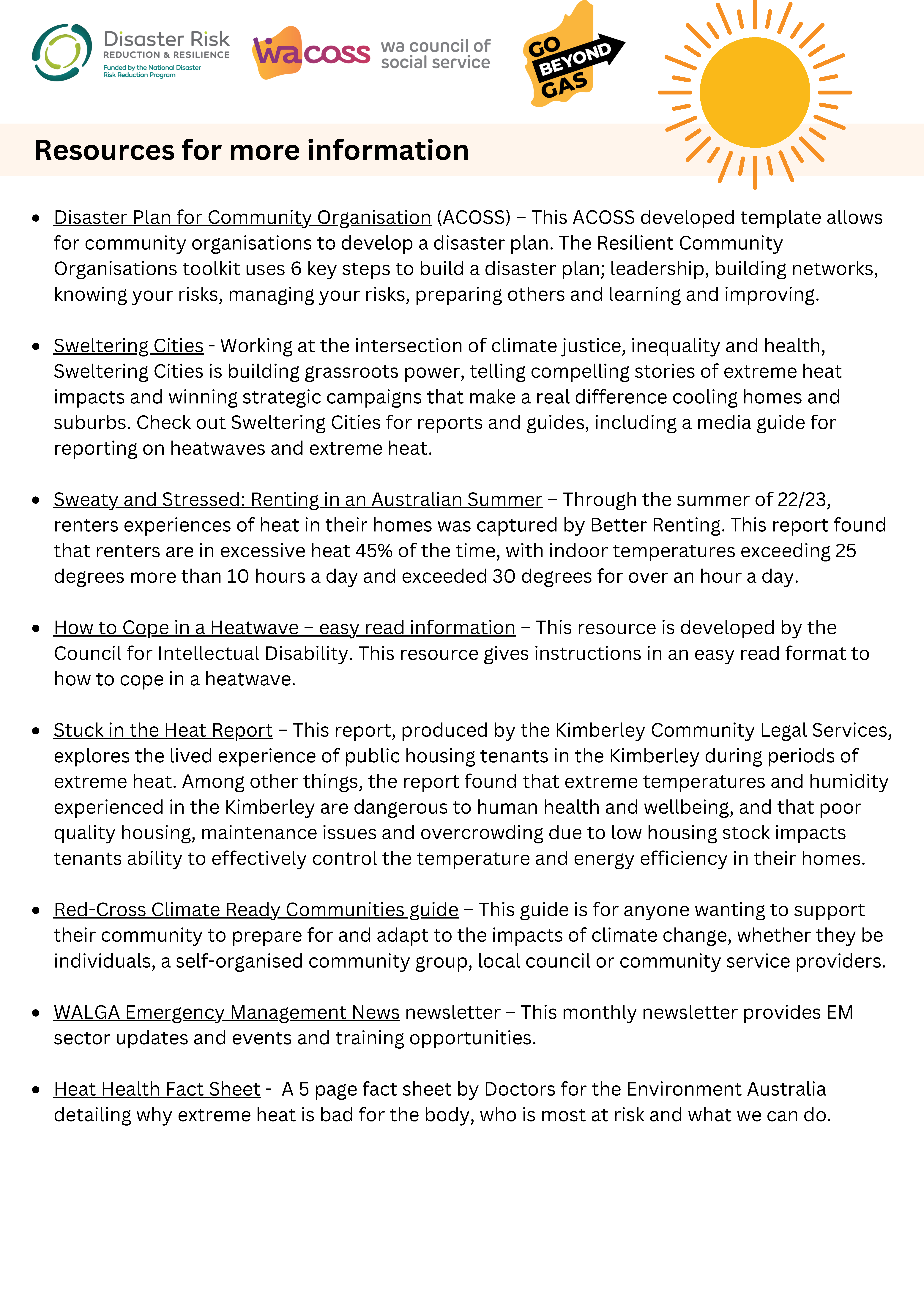
Resources
How to be Engaged Fact Sheet
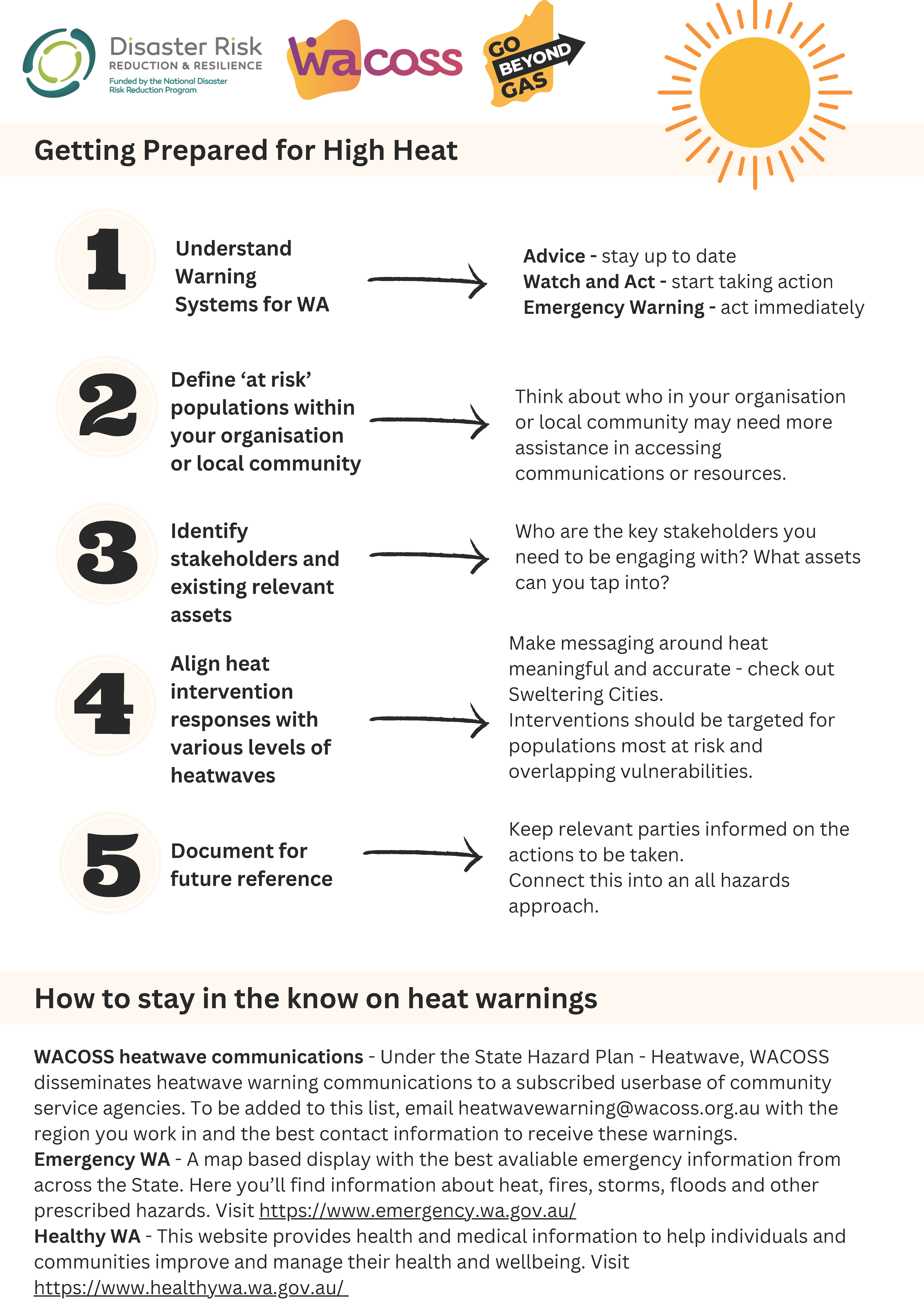
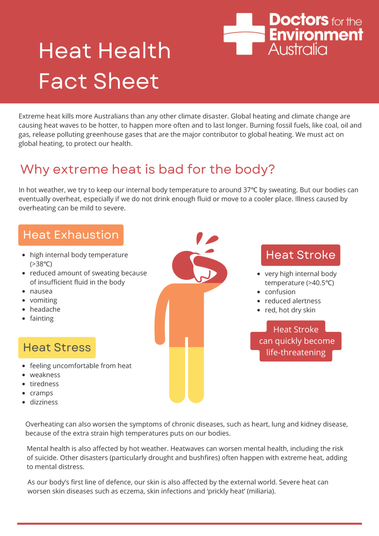
Heat Health Fact Sheet
This resource was shared at the event, Feeling the Heat: Stories and Strategies for Western Australia’s Rising Temperatures as a tool to get prepared for high heat.
Protect your health during extreme heat.
Source: Doctors for the Environment Australia
This project has been funded by Commonwealth Funding through the National Disaster Risk Reduction Grant Programme, distributed through the State Emergency Management Committee